Server check!
You are on the training database

Rights Holder: The Portable Antiquities Scheme
CC License: ![]()
Image use policy
Our images can be used under a CC BY attribution licence (unless stated otherwise).
COIN
Unique ID: PUBLIC-4B7538
Object type certainty: Certain
Workflow
status: Published ![]()
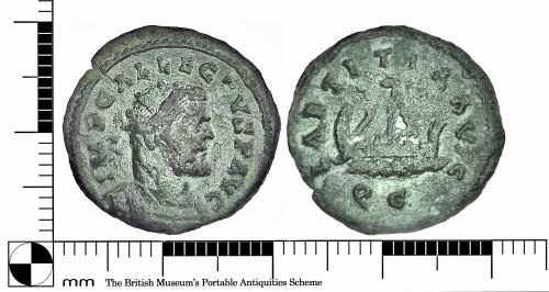
A complete Roman copper alloy Q Radiate of Allectus (AD293-296) (REECE Period14). C mint.
Coin is 19.04 mm diameter, Weighs 2.83 grams, and has a dark- green patina. It has a partial radial-crack at 10-0-clock on the Obverse side.
Find of note status
This has been noted as an interesting find by the recorder.
Subsequent actions
Subsequent action after recording: Returned to finder
Chronology
Broad period: ROMAN
Period from: ROMAN
Period to: ROMAN
Date from: Circa AD 293
Date to: Circa AD 296
Dimensions and weight
Quantity: 1
Thickness: 1.78 mm
Weight: 2.83 g
Diameter: 19.04 mm
Discovery dates
Date(s) of discovery: Wednesday 5th August 2020
Personal details
This information is restricted for your access level.
Materials and construction
Primary material: Copper alloy
Manufacture method: Struck or hammered
Completeness: Complete
Coin data (numismatics)
Denomination: Q radiate
Denomination qualifier: Certain
Reece period: Period 14 [275-296]
Mint or issue place: C mint (Uncertain, England)
Mint qualifier: Certain
Obverse description: Radiate and cuirassed bust right
Obverse inscription: IMP C ALLECTVS P AVG
Reverse description: Galley right with mast, four rowers and no cabin, no waves
Reverse inscription: LAETITIA AVG
Die axis measurement: 6 o'clock
Degree of wear: Worn: fine
RIC Identifier: RIC V Allectus 125
Reverse mint mark: //QC
Status: Regular
Status qualifier: Certain
Coin references
No coin references available.
Spatial metadata
Region: Eastern (European Region)County or Unitary authority: Hertfordshire (County)
District: East Hertfordshire (District)
Parish or ward: Much Hadham (Civil Parish)
Spatial coordinates
4 Figure: TL4416
Four figure Latitude: 51.82407058
Four figure longitude: 0.08804241
1:25K map: TL4416
1:10K map: TL41NW
Grid reference source: GPS (from the finder)
Unmasked grid reference accurate to a 10 metre square.
References cited
No references cited so far.


